
Spatial-RAG – A spatial reasoning capability framework introduced by institutions including Emory University
What is Spatial-RAG?
Spatial-RAG (Spatial Retrieval-Augmented Generation) is a framework developed by Emory University and The University of Texas at Austin to enhance the spatial reasoning capabilities of Large Language Models (LLMs).
It combines sparse spatial retrieval (structured queries on spatial databases) and dense semantic retrieval (semantic similarity matching via LLMs) to address the limitations of LLMs in processing and reasoning over spatial data.
Spatial-RAG applies a multi-objective optimization strategy to balance spatial constraints and semantic relevance, enabling LLMs to generate coherent, natural language responses.
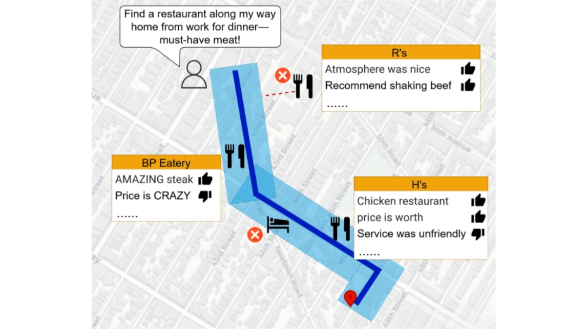
Tested on real-world tourism datasets, Spatial-RAG significantly improves the accuracy and practicality of answering spatial questions, offering new technological pathways for fields like geographic Q&A, urban planning, and navigation.
Key Features of Spatial-RAG
• Spatial Data Retrieval
-
Retrieves spatial objects from spatial databases based on spatial constraints such as distance, direction, and topological relationships.
• Semantic Understanding and Matching
-
Understands the user’s semantic intent through natural language processing and matches it to spatial object descriptions to ensure semantic relevance.
• Multi-Objective Optimization
-
Dynamically balances spatial relevance and semantic relevance to generate the optimal answer that satisfies both spatial constraints and user semantic preferences.
• Natural Language Generation
-
Integrates retrieved spatial and semantic information to generate coherent and accurate natural language responses, enhancing user experience.
• Adaptation to Complex Spatial Tasks
-
Supports complex spatial reasoning tasks such as geographic recommendation, route planning, and spatial constraint searches, making it applicable to tourism, navigation, urban planning, and more.
Technical Principles of Spatial-RAG
• Sparse Spatial Retrieval
-
Parses natural language queries into spatial SQL queries to retrieve candidate objects from a spatial database.
-
Supports various geometric types (points, lines, polygons) and spatial relationships (distance, containment, intersection), ensuring retrieval precision.
• Dense Semantic Retrieval
-
LLMs extract semantic features from both user queries and spatial object descriptions.
-
Computes semantic relevance using text embeddings and cosine similarity.
-
Combines spatial and semantic information to rank candidate objects.
• Hybrid Retrieval Mechanism
-
Integrates sparse spatial retrieval and dense semantic retrieval.
-
Ensures positional accuracy while maintaining high semantic matching, using weighted fusion of both retrieval results to enhance overall retrieval robustness and accuracy.
• Multi-Objective Optimization and Dynamic Trade-off
-
Constructs a multi-objective optimization problem that dynamically adjusts the weights of spatial relevance and semantic relevance.
-
LLMs dynamically decide the balance based on the context of the user’s query to generate the optimal answer.
• LLM-Guided Generation
-
Based on the retrieved spatial and semantic information, the LLM generates natural language answers that ensure spatial logic consistency and linguistic coherence.
Project Information
• Technical Paper on arXiv: https://arxiv.org/pdf/2502.18470
Application Scenarios of Spatial-RAG
• Tourist Attraction Recommendation
Recommend nearby attractions, restaurants, or hotels based on the user’s location or travel route.
• Intelligent Navigation
Optimize route planning by combining real-time traffic information and user preferences, suggesting points of interest along the way.
• Urban Planning
Analyze urban spatial data to assist in the layout planning of facilities such as parks and hospitals.
• Geographic Q&A
Answer geography-related questions, including distances, locations, and landmark information.
• Logistics and Delivery
Optimize delivery routes to ensure on-time parcel delivery.
© Copyright Notice
The copyright of the article belongs to the author. Please do not reprint without permission.
Related Posts


No comments yet...